Amazing images from the sky: Kartoffelraekkerne in Copenhagen

sources of images: Facebook and Instagram, via https://drivemagazine.ro/, https://kartoffelraekkerne.dk/ et al.
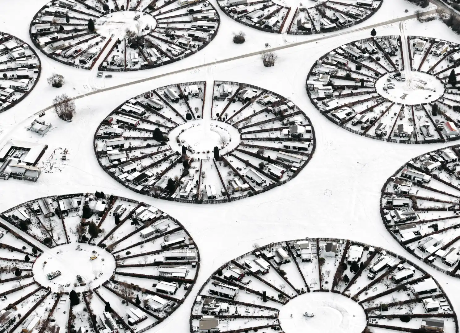
Copenhagen's Quirky Charm: Soaring Over the "Field-of-Potatoes"
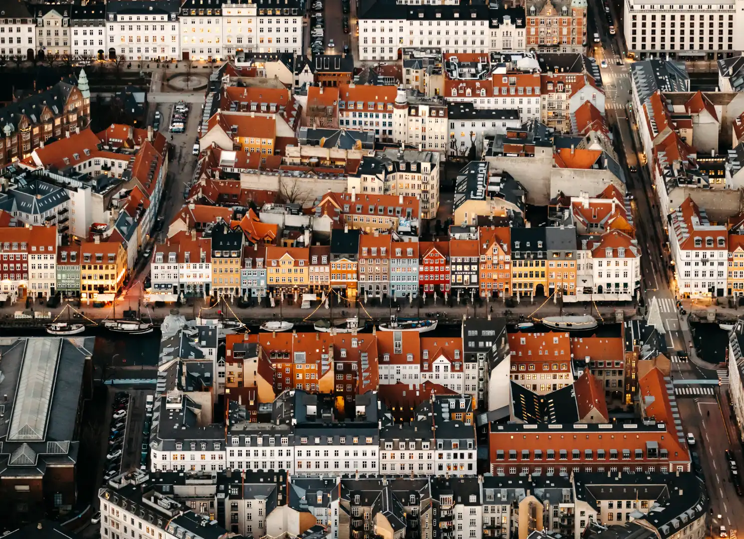
Copenhagen is a city that beautifully blends modern design with its rich history. Beyond the sleek harbors and cutting-edge architecture, lies a charming district with a character all its own, often described as the “architecture field-of-potatoes.” Tucked between Øster Søgade and Øster Farimagsgade, this unique area offers a delightful, slightly chaotic visual experience when viewed from above. But what exactly gives this neighborhood its distinctive name and why is it so beloved?
A Patchwork Quilt of History
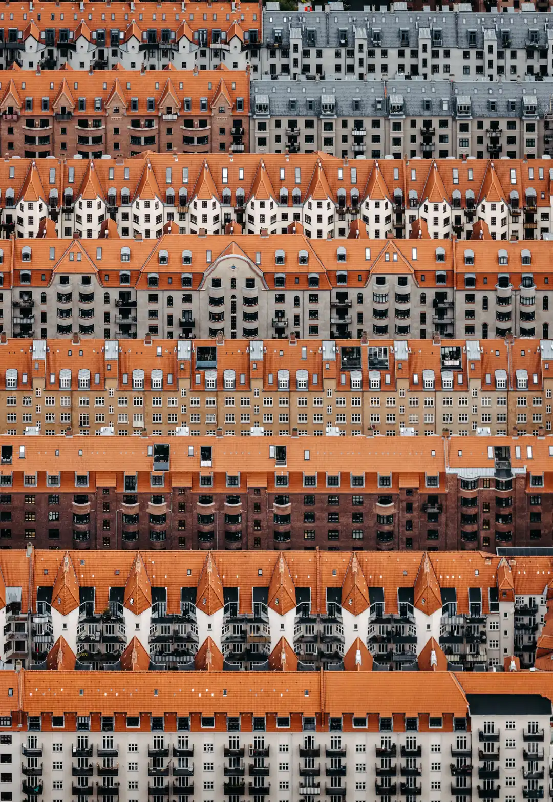
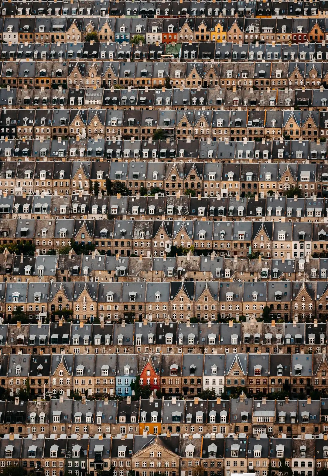
The “field-of-potatoes,” is not a derogatory term. It's a loving nod to the slightly haphazard, wonderfully varied collection of older buildings that dominate this section of the city. From an aerial perspective, these homes – each a unique size, shape, and design – sprawl out like potatoes scattered across a field, giving the area its unusual, almost endearing, moniker. This irregular density isn’t a result of haphazard planning; instead, it’s the outcome of centuries of incremental development, with individual plots and structures gradually expanding and intertwining over time.
Unlike more modern urban plans with regimented street grids and uniform facades, the houses here are characterized by their lack of uniformity. You’ll see varying rooflines, window patterns, and architectural styles crammed side by side. Red brick stands shoulder-to-shoulder with stucco and stone. The overall impression is of a living, breathing piece of history – a testament to the slow and organic growth of a city.
Discovering the Character From Above

From the ground, these buildings tell a story of community and intimate living, but it’s truly when you see it from the sky that you gain a deep understanding of why it is named the “field-of-potatoes.” The satellite view reveals the intricate tapestry created by these structures and courtyards, with smaller side streets that meander amongst the housing blocks. The variation in roof shapes is striking, making each rooftop feel unique – an array of colors and patterns stretching as far as the eye can see.
When exploring aerial photos via resources like Google Maps, Krak (the Danish mapping service), or other mapping tools, be sure to pay close attention to the following details:
- Irregular Layout: Note the dense, almost jumbled arrangement of buildings, giving it the characteristic 'potato field' look.
- Diverse Roof Types: Spot the differences in the roofs - some pointed, some flat, tiled, metal etc.. They create an almost sculptural landscape.
- Street Pattern: You will notice the small side streets, courtyards and how everything intertwines within.
- Texture of the built environment: Different wall materials -brick, stone and different plasters
It’s from this bird’s-eye perspective that you get a true sense of the area’s unique charm and why locals often use this analogy when referring to the space.
Dedicated photographs:
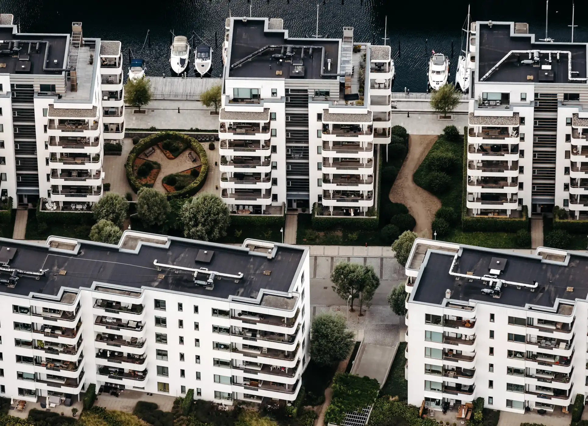
Nicolas Cosedis has made it his mission to capture Copenhagen in the best possible way. He calls his pictures, which are taken hand-held from the air flying in a small Cessna 172, a declaration of love in the genre of "magical realism".
The images are accompanied by texts by architecture critic Holger Dahl, who with his in-depth knowledge of the city and its architecture complements Nicolas Cosedis' photographs and gives the reader new perspectives on Copenhagen.

A truelly manifesto
The "field-of-potatoes" isn't just an interesting architectural quirk – it's a testament to Copenhagen’s past. It serves as a vibrant contrast to the more modern, meticulously planned parts of the city. It's a tangible reminder of Copenhagen’s heritage and a valuable lesson on the organic evolution of city planning (or the lack thereof!). The area offers visitors and locals alike the chance to witness something both uniquely Danish and visually striking.For anyone who enjoys exploring the intricacies of cities and appreciates a healthy dose of unconventional charm, the “field-of-potatoes” of Copenhagen is a must-see. From ground level it has an atmosphere and unique vibe; however from above, this seemingly unordered jumble comes to life to showcase an incredible urban planning aesthetic. The area’s charm comes alive through this perspective as each ‘potato’ finds its place within a fascinatingly arranged composition.
Getting Your Bird's Eye View:
If you’re itching to see it for yourself (virtually for now, but maybe in person soon!), use resources like:
- Google Maps (Switch to satellite view and explore the area between Øster Søgade and Øster Farimagsgade).
- Krak (krak.dk) - A dedicated Danish mapping service often has very sharp and detailed images. Look for "Luftfoto".
- Other mapping services: Bing maps or Apple Maps also often provide an aerial perspective
Use the search terms provided in this blog to see if there are photos on specific sites, and enjoy getting lost in the architectural maze. It is an experience in and of itself to just explore the area online.
So, the next time you are virtually exploring the beauty of Copenhagen or even when you are strolling around the city, look up or find your aerial viewpoint online to really see and discover how the history, character and vibe truly all comes together!
Aerial paintings before aerial photos
It is worth mentioning that such images have an aesthetic that enters into dialogue with the amazing paintings of Egon Schiele. Even if he did not travel that far in the north, and his paintings are restricted, as a subject, to central Europe, his perception of urban spatiality, especially when it comes to a city in Germanic architectural space, directly or indirectly influences today's aerial photo.

By Egon Schiele - Museo Thyssen-Bornemisza, Madrid, Colección Permanente, Public Domain, Link
What do you think of this type of older architecture and city plan? Do you have an area like this near you? Share in the comments below!


.jpg)


Comments
Post a Comment